In the last foothills of the Jura
DIDIER HEUMANN, ANDREAS PAPASAVVAS
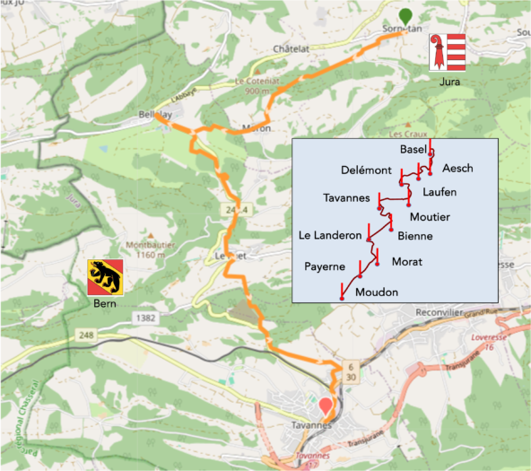
We divided the course into several sections to make it easier to see. For each section, the maps show the course, the slopes found on the course, and the state of the route (paved or dirt roads). The courses were drawn on the « Wikilocs » platform. Today, it is no longer necessary to walk around with detailed maps in your pocket or bag. If you have a mobile phone or tablet, you can easily follow routes live.
For this stage, here is the link:
https://fr.wikiloc.com/itineraires-randonnee/de-sornetan-a-tavannes-par-la-via-jura-80-189577429
| It’s clear that not all travelers are comfortable using GPS and navigating via smartphone, and there are still many areas without an internet connection. As a result, you find a book on Amazon that covers this journey.
If you only want to consult lodging of the stage, go directly to the bottom of the page. |
|
Tavannes is a cradle of quality watchmaking. In 1891, Henri Frédéric Sandoz from Le Locle established a watch company here, which became the Tavannes Watch Co in a building funded by the local bourgeoisie. As early as 1892, Sandoz was among the first Swiss business leaders to import machine tools from the United States. By 1913, the company employed 1,000 workers and produced 2,500 watches per day. Tavannes Watch Co eventually sold millions of watches through its subsidiary, Cyma SA. The loss of the Russian market (1917) and the economic crisis of the 1930s brought the company to the brink of bankruptcy in 1935, but it rebounded during World War II. Its workforce shrank from 2,000 employees before the crisis to 1,200 in 1936. The company gradually declined and was acquired in 1966 by Ebauches SA and Chronos SA.
In its early years, Tavannes distinguished itself by producing high-quality watches in large quantities, an impressive feat at a time when most watches were crafted individually. In 1905, the company launched its first wristwatch, foreseeing a trend that would become global several decades later. This innovation marked a turning point for the brand, establishing it as a pioneer in wristwatches. During the 1920s, Tavannes underwent massive expansion, becoming one of the world’s largest watch manufacturers. By 1923, the company had produced over two million watches. It was also during this period that Tavannes introduced iconic models, including watches with complications like chronographs and moon phases, which are now highly prized by collectors. In the mid-20th century, Tavannes continued innovating, with one of its most notable achievements being the development of a watch capable of withstanding extreme conditions. In 1937, they launched the « Cyma Watersport, » a revolutionary waterproof watch that set new standards for watches designed for nautical activities and extreme sports. During World War II, Tavannes played a crucial role in providing robust, precise watches for the armed forces of several countries, creating military watches designed to withstand tough conditions and ensure reliability, which was essential for wartime operations. After the war, like many Swiss brands, Tavannes faced the quartz watch’s arrival and the subsequent watchmaking crisis. However, the brand was revived in the early 2000s, focusing on producing high-precision mechanical watches using modern techniques while preserving traditional heritage and craftsmanship. Today, Tavannes continues to produce watches that meet the high standards set by its founders, blending traditional design with modern technological innovations. Their commitment to excellence and quality remains central to their brand philosophy, making them a respected and admired figure in the watchmaking industry. Since 2008, a passionate couple has revived the brand, once again producing timepieces under the Tavannes Watch label, Sandoz’s flagship of the past century, albeit on a much smaller scale.
But it’s not only watches that define the Jura Highlands. There’s also the famous cheese, “Tête de Moine” from Bellelay. The history of this cheese dates back to the Middle Ages. Documents from the late 12th century, around fifty years after the founding of Bellelay Abbey, suggest that cheese was already being made at that time. The product was used as a form of payment, to pay farmers’ dues to landowners, as a gift to foster relations, or to settle disputes. However, the first documents explicitly mentioning such production date back to the late 14th century. In 1797, the monks were expelled from the abbey due to the turmoil of the French Revolution, but cheese production continued on the dairies of the abbey’s former estates. By the end of the 18th century, Bellelay cheese was renamed « Tête de Moine. » Why give cheese such a name? According to stories told in the Jura canton, the name refers to an old custom practiced at the abbey. Each year, the prior received a certain quantity of cheese stored at the Abbey for each monk’s head. Another version says that the French Revolution soldiers found cheese wheels in Bellelay Abbey’s cellar after expelling the monks. They scraped off fine slices from the cheese surface, which reminded them of monks’ tonsures, leading them to name the cheese “Tête de Moine.” The cheese can be shaved using a knife, which was the technique before the invention of the girolle. This involves placing the tool at a right angle on the scraping surface and turning it in a circle, though the old method requires much more time and skill. The cheese remained relatively unknown until the introduction of a specialized tool for creating rosettes or curls: the Girolle, invented in 1982 by precision mechanic Nicolas Crevoisier. This device has a central axis that pierces the cheese wheel, around which a blade is manually rotated, producing shavings resembling chanterelles. This invention positively impacted the growth of production and consumption of this semi-hard Swiss cheese worldwide. The Girolle has become so famous that even Chinese manufacturers produce them.
According to the segment plan, today will be a short stage. However, many pilgrims choose longer stages. It’s all about finding accommodation each evening. So, you will go from Sornetan to Tavannes, passing through Bellelay, before heading tomorrow toward the lakes of the Swiss Plateau.
.

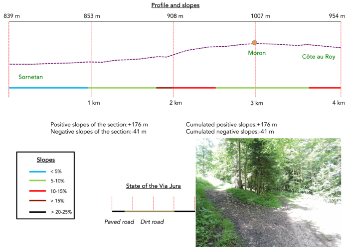
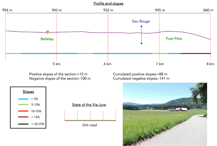
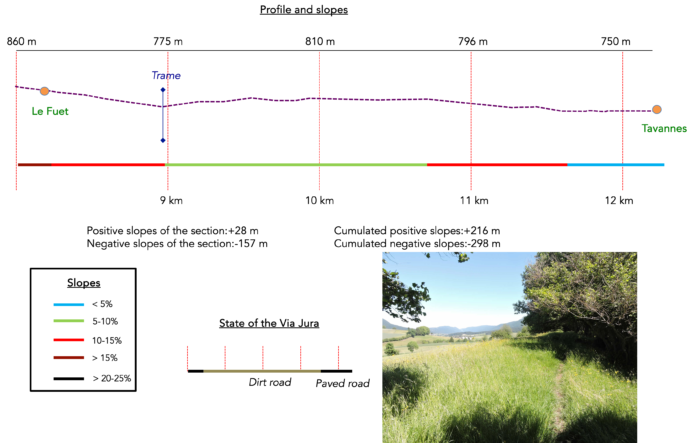
Difficulty level : Today’s route has gentle slopes (+216 meters/-298 meters) and is only 12 kilometers long. There are a few steeper sections, such as the climb towards Moron or the descent toward Le Fuet, but overall, it’s an easy, invigorating route. The route remains entirely within the Bernese Jura.
State of the Via Jura : Once again, today’s route favors paths, as throughout the Jura crossing:
- Paved roads: 3.0 km
- Dirt roads : 9.3 km
Sometimes, for reasons of logistics or housing possibilities, these stages mix routes operated on different days, having passed several times on these routes. From then on, the skies, the rain, or the seasons can vary. But, generally this is not the case, and in fact this does not change the description of the course.
It is very difficult to specify with certainty the incline of the slopes, whatever the system you use.
For those seeking « true elevations » and enthusiasts of genuine altimetric challenges, carefully review the information on mileage at the beginning of the guide.

Section 1 : On the Path of Pastor Frêne

Overview of the route’s challenges : gradual and mild slopes for the most part, with a few exceptions.
Sornetan, a true crossroads of paths in this peaceful region, offers travelers the chance to explore the preserved landscapes of the Jura. At the village exit, the “Perrefitte Variant” merges with the Via Jura 80/91, descending gracefully from the Moron Tower. From here, your route can take either trail, both leading onward to Bellelay and reaching Le Fuet. As noted on the new sign, this is where the route descends from Moron Tower. However, your route continues straight ahead to the end of the village.

|
The route detours for a while along a small country paved road towards Le Fuet, brushing past the serene Protestant center. |
|
 |
 |
| It soon joins the « Path of Pastor Rémy Frêne, » named in honor of this famous 17th-century pastor, whose chronicles capture the essence of daily life in these hills. | |
 |
 |
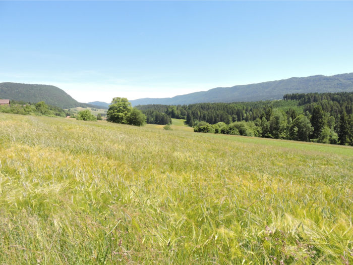
| Initially, the path, inaugurated in 2012, stretches almost flat, with a gentle slope through meadows, accompanied by peaceful cows, gradually leading you toward the shelter of the forest. Here, nature is gentle and welcoming, wrapping you in its tranquil embrace. |
|
 |
 |
| As you approach the forest, the path begins to climb, appreciated equally by hikers and riders. Tall beech trees, like arrows, and thoughtful spruces dominate the landscape, while a few maples add their hues. Oaks and chestnuts, however, are mostly absent from these Jura forests, giving this woodland a unique charm. | |
 |
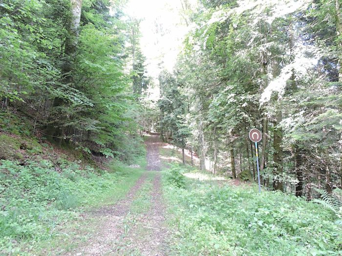 |
| Along the path of the good pastor, the incline becomes steeper, though it never exceeds a 15% grade. The mixed forest sometimes closes in around you, and wild grasses occasionally overrun the path, adding a touch of mystery. | |
 |
 |
 |
 |
| Upon leaving the forest, a wide dirt path then slopes up more gently, with a steady incline along the edge of the woods. The climb is quite long, but in good weather, it is a pleasure to stroll here, bathed in the soft light that caresses the horizon. The Jura landscapes reveal their full splendor as the softer sun hides behind the trees. | |
 |
 |
| The path reaches much higher up Moron, situated on a high plateau, amid grazing cattle. The variety of herds is striking, with mixed-breed Simmental and Holstein cows of all colors adding life to these vast, lush meadows. | |
 |
 |
From here, you can also ascend the Moron Tower, of course!

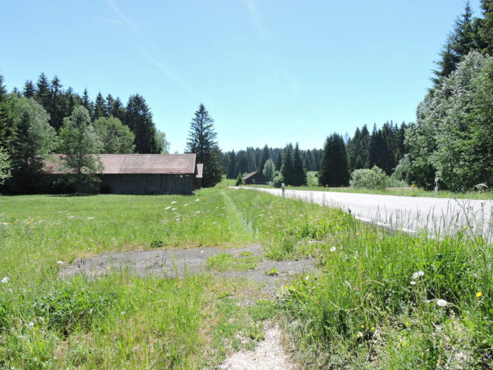
| The Via Jura 80/91 runs through the village on a paved road, bordered by a few scattered farms, affirming the essentially agricultural character of this place. | |
 |
 |
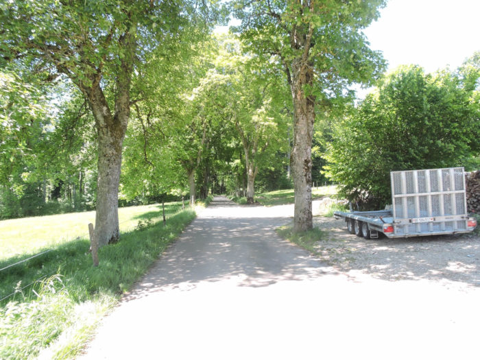
| From this point, the road descends toward Bellelay, lined by majestic plane trees, then softens in the woods, where spruces still dominate. It feels like a change of scenery, leaving the wilderness of previous days for a more civilized, tamed landscape. | |
 |
 |
| Lower down, between scattered woods and open meadows, the landscape opens onto the magnificent Bellelay plain, nestled between vast forests. | |
 |
 |
| At the base of this descent, you reach the place known as La Côte Au Roi, along the road connecting Tavannes to Bellelay. From here, you’ll clearly see the imposing Bellelay Abbey and the Maison de la Tête au Moine, though the marked route does not officially lead you there. | |
 |
 |
Section 2 : Passing through Bellelay toward the Fuet Pass

Overview of the route’s challenges : very steep slopes beyond Fuet Pass.
|
If you’re not pressed for time, take a moment to explore this treasure. Just a few hundred meters away, along a path parallel to the route, you’ll find the Maison de la Tête de Moine, an unforgettable stop for enthusiasts of unique traditions and flavors. It was here that the canons of Bellelay created the famous “Tête de Moine” cheese, known for its unique enjoyment method: it’s shaved into delicate rosettes or petals, rather than simple slices, using a rotary knife called a “girolle.” For over 800 years, this cheese has captivated taste buds, its global reputation drawing both Swiss and international visitors eager to savor this gem of local heritage. |
|
 |
 |
|
For those curious about the secrets of this legacy, the Maison de la Tête de Moine opens its doors. This imposing building, erected in 1768, now houses a museum, an old-time cheese dairy, and an aged cellar that still echoes with the centuries of history it holds. It’s a vibrant place, a tribute to a history full of anecdotes, traditions, and unique craftsmanship, with an influence reaching markets on distant continents. The site is also adorned with unique sculptures of masoned straw, celebrating the monks and surrounding alpine pastures. At the center, you’ll find a jovial-looking monk surrounded by Alpine horn players, frozen in a scene that seems to invite music to complete the local ambiance. |
|
 |
 |
 |
 |
|
Nearby, at a crossroads where new houses have risen in recent years, stands a renowned hotel-restaurant, offering travelers a warm, authentic place to rest. |
|
 |
 |
|
The name « Bellelay » itself, meaning « beautiful forest » in low Latin (« bella lagia »), resonates as a promise of grandeur and serenity. Founded in the early 12th century by the Premonstratensians, the abbey symbolized an era when monks, guided by Saint Norbert’s principles, sought to transform swamps into fertile land. Often burned down, yet always rebuilt, the abbey seen today, with its majestic baroque architecture, reflects the splendor of the late 17th century, at the brotherhood’s peak. Rich yet generous, the abbey welcomed pilgrims, offered bread to the needy, and cared for orphans. The spirit of the Reformation seems never to have reached here, as though the Jura preserved a form of spiritual independence. In 1798, however, the French Revolution disrupted this peace: the clergy were expelled from the abbey, which changed hands several times, becoming a brewery, stable, warehouse, and glassworks in turn. Over the decades, the abbey found a new role as a psychiatric clinic, until this was transferred to Moutier. Since the late 1960s, the Abbey Church of Bellelay, now an open space for culture, has hosted concerts and exhibitions, thanks to the Abbey Foundation. |
|
 |
 |
To continue on your way, you’ll need to return to La Côte Au Roi along the route linking Tavannes and Bellelay.
|
Soon, a path branches off the route, as if escaping a world ruled by asphalt’s rigid grip. It’s a relief, as passing drivers, too impatient, speed along these straight lines as if testing the rules. In this landscape, the subtle signs feel like a lifeline. The modest yellow sign draws the eye, guiding toward the meadows where nature reclaims its rights. |
|
 |
 |
|
The land stretches here in a vast, damp plain, untamed and marshy. A large protective basin surrounds the area, a precious barrier to preserve this bit of land under environmental pressure. The path ventures into this fragile expanse, winding over modest wooden footbridges placed here as a pledge of respect for this unstable habitat. Underfoot, the boards give way almost imperceptibly, as if whispering the old stories of this mysterious plain. |
|
 |
 |
 |
 |
|
The path then exits this wild world—wild in the fullest sense of the word—reconnecting with the route pulsing with human activity. The contrast is striking, a sudden reminder of civilization. Nature recedes for a moment, giving way to asphalt and the hum of engines. |
|
 |
 |
|
Here, the path crosses the road, cautiously at first, then follows it just slightly off to the grassy edge. It’s a suspended moment, almost apart, where your gaze lingers more on the untamed fringes than the road itself. |
|
 |
 |
|
Then the undergrowth opens, offering access to an entirely different realm: the Sagne peat bog. This place is enchanting, like a natural sanctuary where time seems to stand still. A boardwalk unfolds like a guiding thread, protecting the landscape while inviting discovery. Feet stay dry, protected from the deep peat, while subtle signs along the way reveal the secrets of this rare and precious environment. Here, magic meets the wild. |
|
 |
 |
 |
 |
|
The air, thick with moisture, is filled with scents of wood and damp earth. A dense, almost tropical atmosphere settles around visitors; only the distant call of parrots would complete this illusion of exoticism. Every dewdrop, every blade of grass seems to honor life, a lushness so rare in these latitudes. |
|
 |
 |
Leaving the bog, the route merges into uncertainty. Signs are scarce, and you’ll need to retrace your steps, finding the road with only caution as your guide. The ground here is marshy, riddled with hidden pitfalls under brownish mosses, where each step seems to sink and disappear. If luck favors you, you may glimpse the Eau Rouge stream, a rusty-colored ribbon quietly winding through the marsh, hesitant, as if seeking its own path. You’ll understand its evocative name then, seeming to vanish, absorbed by the land without reaching a river.

|
Although the route is unpredictable and markers rare, it’s almost impossible to get lost here. The path follows the road, veering off occasionally but keeping a respectful distance. Spruces, like sentinels, stand along the path, creating a scene that feels like a Christmas setting. Beneath thick layers of moss, chanterelles likely thrive in season, adding their secret to the landscape. Next to them, tall maples mingle with conifers, spreading their leafy branches as if to soften the sharpness of the needles. |
|
 |
 |
|
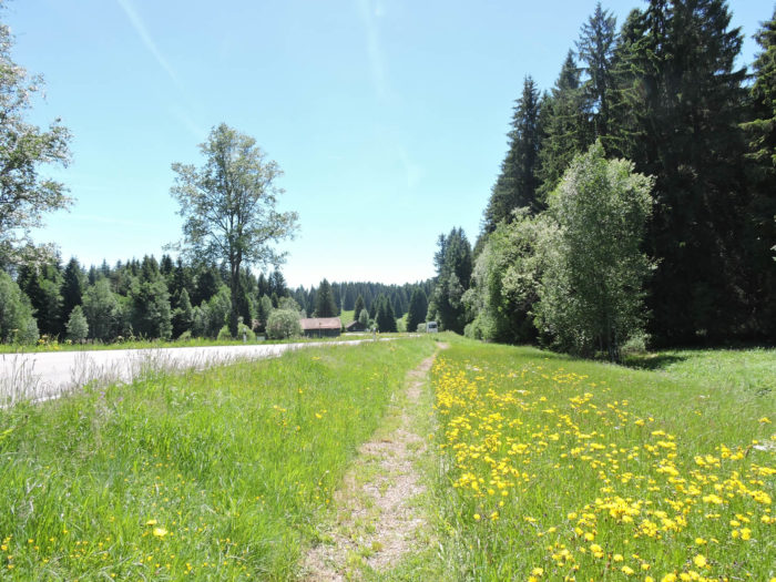
The path gradually gains elevation, climbing through meadows under the road winding toward the Fuet Pass. Though present and invasive, the road seems less intrusive in this vibrant nature, and the walk, lulled by the meadows’ murmur, becomes almost meditative. |
|
 |
 |
|
Soon after, the path joins the pass road. Here, the incline is never steep. |
|
 |
 |
|
The path winds again, closely following the road that leads toward La Bottière. This is a key junction for hikers and pilgrims, with the option of a detour toward Moron Tower, a stone sentinel that seems to invite contemplation. At the pass, which is more a namesake than a true pass, one is struck by the peaceful simplicity of this place, as if suspended between earth and sky. |
|
 |
 |
|
The path follows the road for about a hundred meters until a new fork appears. Here, the two Via Jura routes diverge, and choosing your path carefully is essential. Via 91 heads toward Tramelan, while Via 80—your route—takes the direction of Tavannes. Here you sense the region’s complexity, where paths multiply and intersect, often confusing foreign visitors and even seasoned pilgrims venturing into these winding lands. |
|
 |
 |
|
Once more, the path lingers in the meadows along a chaotic trail that skirts the bustling road. Each step feels hesitant, sensing the tension between the calm of the fields and the road’s agitation. |
|
 |
 |
|
Just a few meters further, a new fork appears, allowing you to climb back up toward Moron Tower. However, your route, Via Jura 80, stays straight, determined, slipping under the road into the meadows. A gate crossed to hold back cattle, and a new world opens—a place that feels like a welcome into the wildness of the land. |
|
 |
 |
|
Finally, the path approaches the road one last time before disappearing into the forest toward the village of Le Fuet. |
|
 |
 |
|
It begins as a narrow path, winding ever more intensely under limestone cliffs. The nature here is wild, nearly untamed, and you advance cautiously, as though every step were watched by the ancient spirits of the woods. The atmosphere grows heavy, an exhilarating solitude enveloping the surroundings. |

|
Further down, the path seems to momentarily disappear, swallowed by the bushes and wild grasses flourishing in fascinating disorder. |
|
 |
 |
|
Then, the descent resumes with vigor, through dense forest and thickets. The trees, increasingly large and majestic, dominate the path, until suddenly, through a break in the foliage, the village of Le Fuet appears below, almost surreal, like a promise. |
|
 |
 |
 |
 |
Section 3 : Descent toward Tavannes in the plain

Overview of the route’s challenges : This route mostly consists of long downhill stretches, without major difficulties.
|
At the bottom of the steep descent through the meadows, the path eventually reaches the first houses of the village, nestled like a secret in the slope’s hollow. |
|
 |
 |
|
Le Fuet clings to the mountainside, a modest yet proud village, with its newer church whose steeple timidly pierces the sky, a small school with weathered shutters, and a bell tower that seems to watch over the souls of the place. From here, you can also climb the path leading to the famous Moron Tower, but for now, the direction is Tavannes, an hour’s walk away. Here, in the heart of the Jura, horses reign supreme, imposing their nobility even in the meadows, where they sometimes seem to overshadow the cows. This land is renowned for its robust, proud horse breeds. |
|
 |
 |
 |
 |
|
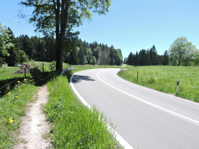
Leaving the village, a paved road gently descends into a small plain where the Trame stream meanders. Behind the oat fields, the Jura hills unfold, offering a panorama ruled by wild beauty, a living tableau that seems to defy time. |
|
 |
 |
|
In the valley’s depth, the Trame flows discreetly, a thin ribbon of water lost in the marshlands, winding quietly but with a nearly soothing gentleness. |
|
 |
 |
|
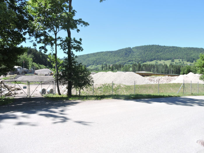
A path quickly heads into the underbrush, entering the cool shade of spruces and beeches, where nature reclaims its domain, enveloping the traveler in silence and mystery. There, beyond the trees, an imposing recycling complex and a gravel pit come into view, human structures that stand in stark contrast to the peacefulness of the surroundings. |
|
 |
 |
|
To avoid them, the path cleverly branches through the forest, bypassing the installations with discretion, like a sage intent on preserving the serenity of nature. |
|
 |
 |
|
Upon exiting, a small paved road unfolds on the other side, like an invitation to continue the journey. |
|
 |
 |
|
It then merges with the main road leading to Tavannes, lined with a narrow strip of grass, a last breath of green before the more formal path. |
|
 |
 |
|
At times, a wild path flirts with the road, diving into the tall grass, playing hide and seek with the pavement before disappearing again into the vegetation. |
|
 |
 |
|
Then it returns to the heart of the forest, dense and mysterious, as if offering a final refuge in rich nature. |
|
 |
 |
Farther along, a true hiking path leads to a tranquil pond, its dark waters reflecting the sky in an almost tropical atmosphere. These ponds, so distinctive to the region, have an exotic allure; one could almost expect an alligator to emerge from the water. But no, only mosquitoes dare to disturb the calm of the surface, modest yet invasive insects, a reminder of the ordinary life that persists here despite the grandeur of the place.

|
A few steps away, a picnic area has been set up under the soothing cover of the trees, offering hikers a charming, shaded resting spot. |
|
 |
 |
|
A little farther, the path leaves the forest’s shade and stretches across the meadows, winding along a ridge that overlooks the town of Tavannes, offering a breathtaking view of the scattered rooftops below. |
|
 |
 |
|
Below, the paved road and the railway slide alongside each other like parallel ribbons, heading toward Tavannes, a reminder that, despite the mountains’ tranquility, modernity is never far away. |
|
 |
 |
 |
 |
|
Farther down, a dirt road winds down the hill, skirting lush green meadows that dominate the landscape, with occasional wooden fences and sparse crops breaking the green monotony. |
|
 |
 |
|
The Via Jura then reaches the heights of the town, on a small, peaceful plateau from which one can survey the surroundings—a natural vantage point inviting contemplation of the landscape. |
|
 |
 |
|
It then slopes gently down to join the Birse River, which here discreetly flows underground, hidden from view but ever-present in local history. |
|
 |
 |
|
The route then heads toward the station, nearing the town center. Tavannes, with its current 3,500 inhabitants, remembers a more prosperous time when its population exceeded 4,000 in the 1960s, bearing witness to more flourishing days. |
|
 |
 |
On this route, you will encounter a famous Swiss memorial commemorating the history of Tavannes Watch Co. This watchmaking company, founded in 1895 and active until 1966, left a lasting mark on the Bernese Jura and exported millions of watches worldwide. The story of TWC is an industrial epic: it saw a meteoric rise, followed by a rapid decline. It all began in 1891, when Henri-Frédéric Sandoz, an entrepreneur from Neuchâtel, responded to a call to establish a watch factory in Tavannes. Production began modestly, with 42 watches per day and 40 workers. But by 1903, TWC employed 470 people and produced nearly a thousand watches daily.
Growth continued after Sandoz’s death in 1913, with such expansion that by 1938, the company employed 2,000 people and produced 4,000 watches daily. This prosperous period marked the arrival of the first waves of immigration to the Bernese Jura, attracted by employment opportunities. At its peak, TWC was the largest watch factory in Europe, even innovating socially with the introduction of the English week and a mutual aid fund for employees.

|
Over time, the factory grew, and other workshops bearing the Tavannes Watch name emerged in Switzerland. However, financial challenges and patent restrictions accelerated the company’s decline. In 1948, the “Tavannes” name was replaced with “Cyma” on dials, yet loyal customers still demanded their Tavannes watches. The decline quickened, followed by successive acquisitions until the factory closed. Today, only a small parts-turning operation for watch components remains, a far cry from the glory days. It would be wrong, however, to think that the watch industry is dead in the Jura Arc. This sector remains vital for the region, still providing a quarter of local jobs, along with many cross-border workers. For example, near the old Sandoz factory, Roventa continues the watchmaking tradition with its own watch production. |
|
 |
 |
|
The village of Tavannes, once agricultural, transformed with the rise of the watch industry. The farms in the center disappeared, replaced by more modern buildings, sometimes designed by renowned architects, including Le Corbusier. The grand hotels, some now closed, still bear witness to that prosperous era. |
|
 |
 |
|
On a small hill, the 17th-century reformed church dominates the town, like a steadfast guardian above the main street, still striving to recall the glorious hours of its industrial and watchmaking past. |
|
 |
 |
Accommodation on Via Jura
- Auberge de Bellelay – Hôtel de l’Ours, Bellelay; 032 489 52 52; Hotel, dinner, breakfast
- Hôtel Central, Pierre-Pertuis 1, Tavannes; 032 481 28 55; Hotel, dinner, breakfast
The Jura remains a destination favored primarily by local tourists. As a result, accommodations are more discreet, with the exception of Airbnbs, for which we do not have addresses. On this stage, it is possible to find lodging and dining options in Bellelay, along the route, before reaching Tavannes, a town with all amenities but only one accommodation option. Booking in advance is recommended for safety.
Feel free to add comments. This is often how you move up the Google hierarchy, and how more pilgrims will have access to the site.
 |
Next stage : Stage 7: From Tavannes to Bienne/Biel |
 |
Back to menu |