In a narrow world of road bridges and gorges along the Suze River
DIDIER HEUMANN, ANDREAS PAPASAVVAS
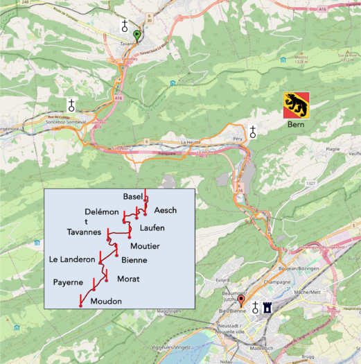
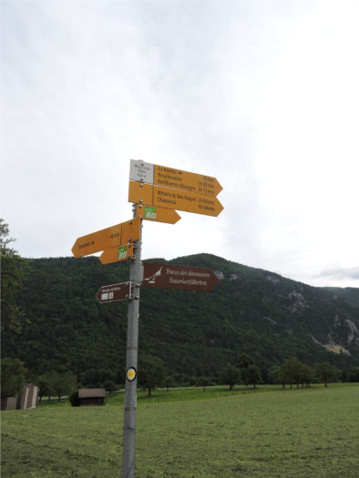
We divided the course into several sections to make it easier to see. For each section, the maps show the course, the slopes found on the course, and the state of the route (paved or dirt roads). The courses were drawn on the « Wikilocs » platform. Today, it is no longer necessary to walk around with detailed maps in your pocket or bag. If you have a mobile phone or tablet, you can easily follow routes live.
For this stage, here is the link:
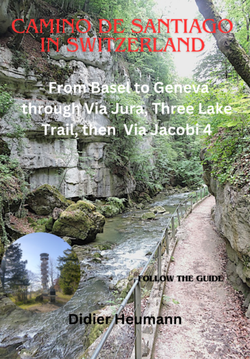
| It’s clear that not all travelers are comfortable using GPS and navigating via smartphone, and there are still many areas without an internet connection. As a result, you find a book on Amazon that covers this journey.
If you only want to consult lodging of the stage, go directly to the bottom of the page. |
|
Today, the route leaves the majestic Jura mountains to descend into the plain. This transition is not without challenges, as the geography of this region is complex and steep. After crossing a small pass and descending toward Sonceboz, the itinerary follows a valley that plunges sharply down, ultimately diving toward Biel (Bienne in French). The Suze, a modest river, has carved its way through the Jura rocks, forming tumultuous waterfalls and deep gorges, enhanced by whirlpools, dizzying cliffs, and suspended promontories. In this wild setting, the pillars of the highway appear like gigantic monsters, sucking up the water of the small river. A local legend tells that the gorges, known as the Taubenloch gorges, got their name from a young woman nicknamed « Little Dove » (« Taube » in German), who is said to have thrown herself there after being torn from her wedding by a bloodthirsty robber. As often in tales, the young girl is of rare beauty, and the robber is a bloodthirsty monster. While crossing these gorges, you will surely be amazed by the beauty and mystery of this unique landscape.
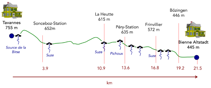
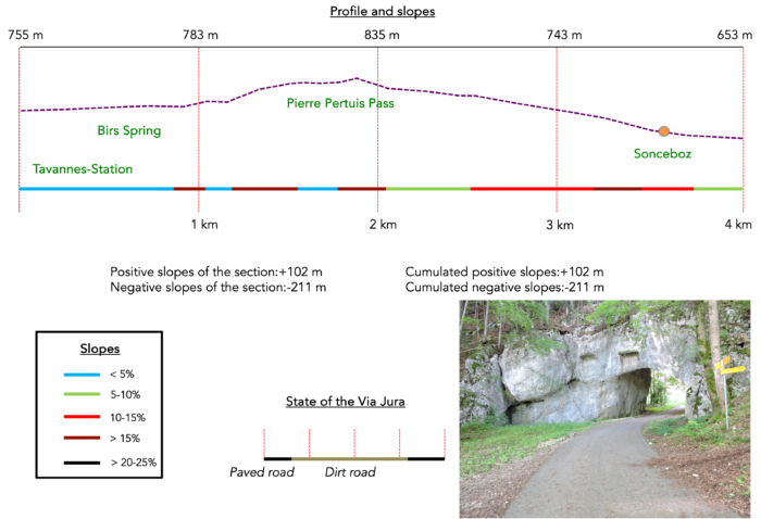
Difficulty level : The elevation changes are more reasonable than in the previous days (+334 meters/-644 meters). It is mainly a descent after a somewhat steep ascent at the Pierre-Pertuis Pass. Then, the descent is often calm, with a few small bumps or marked descents throughout the route, particularly near Heutte and Péry. The path through the gorges is neither perilous nor steep. But this is not an easy stage.
State of the Via Jura : In this stage, the distances on asphalt and on paths are fairly equivalent:
- Paved roads: 11.4 km
- Dirt roads : 10.1 km
Sometimes, for reasons of logistics or housing possibilities, these stages mix routes operated on different days, having passed several times on these routes. From then on, the skies, the rain, or the seasons can vary. But, generally this is not the case, and in fact this does not change the description of the course.
It is very difficult to specify with certainty the incline of the slopes, whatever the system you use.
For those seeking « true elevations » and enthusiasts of genuine altimetric challenges, carefully review the information on mileage at the beginning of the guide.

Section1 : Through the Pierre Pertuis Pass
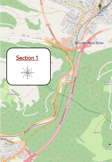
Overview of the route’s challenges : steep slopes both uphill and downhill, often exceeding 15%.
|
Today’s journey begins at the Tavannes train station, a modest station that, through its simplicity, embodies the charm of small Swiss towns. A winding road initially follows the railway line before overlooking it, offering a panoramic view of the surrounding landscape. |
|
 |
 |
Caution here! While you pass through La Heutte, another route resolutely heads toward the mountains. This is not yours. Your itinerary will lead you to the Pierre Pertuis Pass, a prestigious pass, before descending toward Sonceboz, following the historical path of the Via Jura 80.

| The Via Jura discreetly leaves the outskirts of Tavannes, winding along a smooth asphalt road that overlooks the railway tracks. In the blink of an eye, you are propelled out of the city, into a world where nature reigns supreme. | |
 |
 |
| Next, it enters a small country path, guiding you toward the mysterious tunnels of the highway. | |
 |
 |
| Quickly, it reconnects with the railway and passes under one of the ramps of the A16 Highway, a vital artery often hidden underground. It’s important to understand that the geography here is complex. In the past, all traffic passed through the Pierre Pertuis Pass, often causing traffic jams in the narrow valley. Today, the highway has significantly simplified circulation in the region. The pass is now neglected, making way for a smoother road. However, it is crucial to consider the integration of the highway and the ramp leading to Tavannes in this context. | |
 |
 |
| The Birs, the river you are ascending from Basel, finds its source here. It is in the heart of the Pierre Pertuis Mountain that it is born, confined in a locked building, as if to preserve its mystery or original purity. It is not in the midst of grand nature, just below a road viaduct. In large blue letters is inscribed on a display: source of the Birs. A flight of stairs leads there, but the place, resembling a small bunker, is closed. Nothing very spectacular inside, except for an opening in a rock wall where the water flows from the north flank of Pierre-Pertuis. This water is of karstic origin, coming from an underground water flow in the limestone rocks. If the source is closed, it is probably because it supplies drinking water to the people of Tavannes. | |
 |
 |
| A rough little path in the clay leads you up a small steep staircase right above to a paved road, winding towards the pass. | |
 |
 |
Stories of famous travelers who crossed this pass abound here, dating back to the days of the diligences, when this route was essential for crossing from the Jura to the Swiss plateau. This pass is mentioned in Diderot’s Great Encyclopedia, and Goethe himself took this path .

| A little further up, the magnificent Pierre Pertuis rock stands tall (petra pertusa). A pertuis, derived from the late Latin « pertus », refers to a strait between two islands or a narrow passage, such as a mountain pass or gorge. In France, near Vézelay, there is the village of Pierre-Perthuis (Pierced Rock) by the Cure River. | |
 |
 |
Local promoters like to remind everyone of the prestige of this rock. However, they seldom speak of the Latin inscription engraved on the archway of the passage. And for good reason. Here, it is a natural passage, widened since Roman times for the route connecting Aventicum (Avenches) to Augusta Raurica (Basel). An inscription carved into the rock above the pertuis attests to this enlargement in the 3rd century AD. It states: « In honor of the Emperors, this road has been laid out by Marcus Dunius Paternus, Duovir (co-governor) of the Helvetii colony. » Historically, this inscription, engraved on the orders of the magistrate of Avenches, Paternus, confirms that it was during Roman times that the road through the pass was developed. The natural hole in the rock was enlarged to allow passage. A tradition that emerged at the end of the Middle Ages, unrelated to the inscription, attributes the creation of this ancient path to Julius Caesar. Everywhere, grand stories and famous heroes are cherished. But Julius Caesar never passed this way. We would know if he had.
This passage was used until the early 20th century, before the road through the pass, accessible by cars, was built. However, since the opening of the highway in 1997, most travelers no longer take this road pass. Here, you are just 10 minutes from the pass itself.
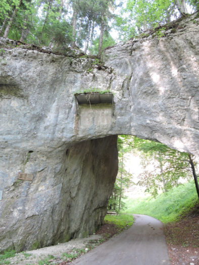
| As soon as you exit the pertuis, the small road swiftly winds up towards the heights of the pass, quickly transforming into a dirt path. Progress is rapid and unexpected, akin to a half-spoken promise, that of a pass that reveals itself only subtly. | |
 |
 |
| Once the path meets the pass road, a green trail emerges, stretching alongside the pass road, like a guiding thread leading the traveler upwards. Here, the valley is steep and enclosed, with little light filtering through. At times, you may feel as if you’re walking at dawn. | |
 |
 |
| Higher up, a steep path climbs, challenging walkers with its steep incline. It ascends several hundred meters above the pass without truly seeming to head there. The pass itself, at 826 meters in altitude, will only be observed from above. Surprisingly, the ascent of the pass by road remains gentle, almost welcoming—a rarity for such an elevation. Here, at 855 meters, you are hardly higher than the pass, following the Via Jura, just 50 minutes from Sonceboz. | |
 |
 |
| The path, still faithfully the Via Jura 80, winds down along a modest road and then on a narrow trail among towering spruces and graceful maples. The limestone barrier of the cliffs before you speaks of nature’s tortuousness in these parts. | |
 |
 |
| Further down, a grassy path discreetly finds its way to the road descending from the pass towards Sonceboz. | |
 |
 |
| The Via Jura then abandons the pass road to its fate and engages in a long descent on packed earth through the forest. Here, the deciduous trees, masters of the place, gradually push the spruces to the background. | |
 |
 |
| Lower down, the path seems to disappear into an abundant nature, weaving through a tangle of beech shoots, alders, and small field maples, creating an almost enchanted atmosphere. | |
 |
 |
| Then, the packed earth path reappears in a more structured manner. The descent is fairly steady, though at times quite steep, with slopes over 15%. Over a span of 2 kilometers, the path drops 200 meters in elevation. When the light is low, the landscape can appear rather dull. Here, however, are some autumn scenes captured in the slanting light. | |
 |
 |
| Over a span of 2 kilometers, the path drops 200 meters in elevation. When the light is low, the landscape can appear rather dull. Here, however, are some autumn scenes captured in the slanting light. | |
 |
 |
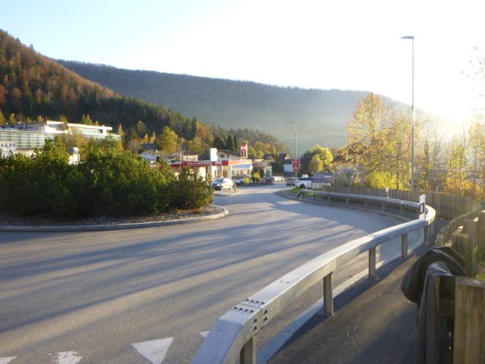
| Further down, the forest begins to thin out, and the path leads to a large roundabout at the entrance to Sonceboz, in an area with industrial and service buildings. At this roundabout, you encounter the mountain pass road, the highway plunging into a tunnel, and the railway. The Via Jura crosses this intersection, heading toward the station. | |
 |
 |
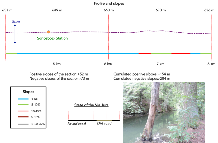
Section 2 : A first stretch along the Suze River
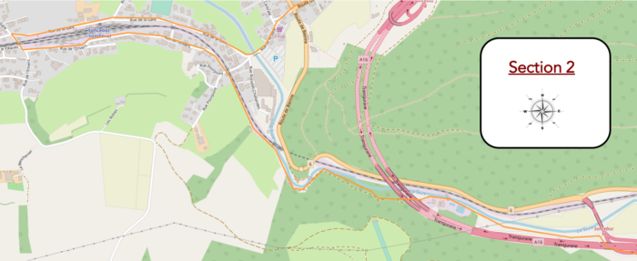
Overview of the route’s challenges : a straightforward course.
|
Here, crossing to the other side of the valley proves to be delicate. Between the imposing rock, the tumultuous river, the moving train, the winding road, and the roaring highway, it is clear that a direct path is not an option. A detour through Sonceboz is necessary. You first take the road to the station, cautiously orienting yourself toward the river. |
|
 |
 |
|
The road crosses the Suze, a river whose source is further upstream in the Jura, specifically in the St. Imier Valley. This river will accompany you all the way to Biel. The road then continues toward the Sonceboz-Sombeval station, reminding you that, in reality, two villages coexist here. |
|
 |
 |
|
However, the illusion of simplicity is short-lived. You must remain vigilant, as the road does not lead directly to the station. The geographical complexity of the area imposes a winding route. |
|
 |
 |
|
The road runs under the railway bridge, emerging on the other side via a street aptly named Rue de l’Envers. Here, the train mimics the walker: after emerging from beneath the Pierre Pertuis Mountain, it makes a large loop before once again following the river. Every small town in the Bernese Jura has a station connected to Biel, a vein of steel and concrete traversing the mountains. |
|
 |
 |
 |
 |
At the end of Rue de l’Envers, the Via Jura leaves Sonceboz to head toward the Métairie de Nidau. This stage requires navigating a narrow and steep valley, a constant challenge between nature and civilization.

|
The railway line elegantly leaps over the Suze River, while the Via Jura engages on a narrow path, running alongside the river through a small, intimate, shaded undergrowth. |
|
 |
 |
|
The vegetation here is dense and lush, overtaking the edges of the railway and the river with its beech sprouts, robust alders, hornbeam shoots, and tangled bushes. |
|
 |
|
 |
 |
The path then gets closer to the river, offering views worthy of pastel paintings or postcards, where every element seems perfectly in place, in natural harmony.

|
The river, peaceful as it approaches a small retention basin, quickly reveals its spirited, cascading nature, returning to its dynamic self. |
|
 |
 |
|
Lower down, the path sneaks under the imposing pillars of the highway. This constant proximity to the highway, although surprising, creates a striking contrast. It is not an ugliness, but rather a kind of industrial gigantism inserted into a troubled nature, where the highway alternates between viaducts and tunnels. |
|
 |
 |
|
A little further, the path reaches a barrier, marking access to a wastewater treatment plant (STEP). |
|
 |
 |
|
You can hear whimsical promises there: in a century, a municipal pool with giant slides will allow people to swim in the waters of the STEP. An obviously ironic but amusing vision. |
|
 |
 |
|
A paved road then takes over, following the river along the access road to the treatment plant, a complex game of highway pillars and barriers. |
|
 |
 |
|
The highway disappears again into a tunnel on the other side of the river, while your route, perfectly marked, heads toward the Métairie de Nidau. |
|
 |
 |
 |
 |
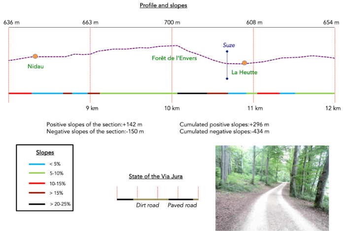
Section3 : Over hill and dale through the forest
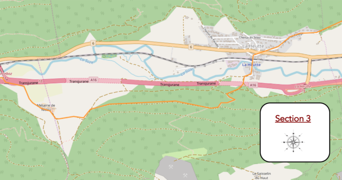
Overview of the route’s challenges : some steep slopes, especially when descending to La Heutte, exceeding 15%.
|
A road slopes up peacefully along a dry-stone wall, winding through meadows toward the farm that stands majestically above. |
|
 |
 |
|
Nestled in the vast domain of Nidau, this place is not just a simple farm; it transforms into a culinary refuge that invites travelers to linger and savor the essence of the surrounding countryside. |
|
 |
 |
|
A dirt trail veers away from the Nidau farm, leaving behind the stone walls to resolutely plunge into the mystery of the forest. |
|
 |
 |
Here, in these woods that resonate with ancestral echoes, ancient history comes to life: fossilized footprints of dinosaurs bear witness to a bygone era, reminding humanity of its fleeting nature in the face of the slow march of time.
|
The wide path climbs steadily for nearly a kilometer, alternating between gently sloping sections and steeper inclines, diving deep into the majestic Envers forest. Here, beech trees unfurl their leaves like frescoes of gold and green, maples cast their protective shadows, while spruces offer their woody fragrance to the breeze caressing the treetops. |
|
 |
 |
 |
 |
At a bend in the path, in the area known as the Envers Forest, the Via Jura decides to abandon the quest for dinosaurs. It is here that exploration opens up to another aspect of nature, less ancient but just as captivating, at least in its rawness and wildness.

|
A path abruptly descends through the forest toward La Heutte, its steep drop forcing the hiker to zigzag between the bushes and wild grasses lining the trail. At the start, the slope is the most dizzying, a descent that challenges balance and demands caution with each step. |
|
 |
 |
 |
 |
|
Lower down, the path opens up, its width increasing as the slope becomes gentler, inviting a sigh of relief from the hikers continuing their journey toward La Heutte. |
|
 |
 |
|
Soon, the first houses of the village emerge on the horizon, the path winding down to cross the river that flows through this peaceful hamlet. |
|
 |
 |

|
A few steps further, a paved road traces its way in front of the station, passing through La Heutte before climbing once again beyond the village. |
|
 |
 |
 |
 |
|
The ascent is sustained, bravely climbing until it reaches the school nestled at the edge of the forest. The children here don’t need gymnastics classes; their overflowing energy transforms them into little erupting volcanoes, sculpting their muscles as artists would shape clay. |
|
 |
 |
 |
 |
|
Further ahead, a wide path appears, gradually sloping up through a forest where majestic beech trees rise like titans. Their imposing presence and lofty stature captivate the eye, offering an unparalleled spectacle of natural beauty as their silhouettes proudly stand, far from the modest dense sprouts that sometimes populate the understory. |
|
 |
 |
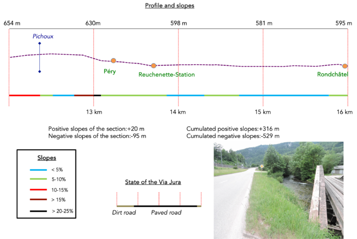
Section 4 : In the Gorge of the Suze River
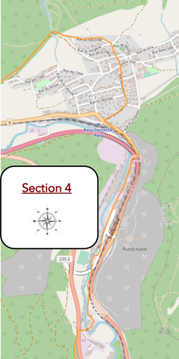
Overview of the route’s challenges : some steep slopes while descending toward Péry, but not difficult.
|
The path stubbornly winds through dense foliage, climbing with a pronounced incline. Beneath the majestic canopy of giant beeches, a welcome coolness envelops the hiker, refreshing each step in this vigorous ascent. Do not be fooled by the apparent gentleness of the Jura, even if it is part of the Pre-Alps; it is not limited to tranquil paths. The trails can reveal challenges worthy of the most intrepid adventurers. |
|
 |
 |
|
As it ascends, the path reveals the graceful falls of Pichoux, their waters captured in emerald serenity, a hidden gem in the embrace of nature. The cascading water descends with voluptuous grace, offering an intoxicating freshness that awakens the senses. |
|
 |
 |
|
From there, a narrow trail briefly descends through the dense forest, brushing off autumn leaves, until it emerges at the first glimpses of the homes in Péry-La Heutte. |
|
 |
 |
|
Below, the deep gorge where the Suze plunges reveals itself, a dizzying scar in the wooded landscape. |
|
 |
 |
 |
 |
|
Continuing down, modest stairs descend determinedly toward the heart of the village, their steps worn by centuries of use and daydreams. |
|
 |
 |

|
The road then unravels its ribbon in all its length through the village, a lively artery that tells the story of a community nestled between mountains, rivers, and the narrow valley. |
|
 |
 |
 |
 |
|
It then descends toward the Reuchenette-Péry station, a crossroads where the murmuring river, the bustling RN6, and the highway quietly burrow underground, a complex blend that immerses you in a mysterious blur, leaving each person to seek their own place in this enigmatic tableau. |
|
 |
 |
 |
 |
|
Here, in this landscape where nature and civilization intertwine their destinies, each step is a symphony of contrasts and harmony, woven by the passage of seasons and the echoes of ancient stories. |
|
 |
 |
|
Here, the topography becomes a complex labyrinth in a narrow valley, where a gigantic cement factory stands imposingly, exploiting the local riches of marl and limestone, obstructing the horizon with its massive structures. It is of raw beauty but undeniable utility, like a rustic tool that, while not appealing, accomplishes its task with formidable efficiency. |
|
 |
 |
|
The Via Jura descends along the national road, weaving like a lifeline through this industrial landscape. To overcome the obstacle, it enters an underground passage beneath the national road, briefly integrating into the heart of the factory itself. |
|
 |
 |
 |
 |
|
Upon exiting this industrial world, the Via Jura follows the access roads, its path traced in the wake of industrial activity. |
|
 |
 |
|
Emerged from the site, it follows the RN6 for a moment along the tranquil banks of the river before veering toward Rondchâtel. |
|
 |
 |
|
It crosses beneath the national road, which snakes through a tunnel, where the incessant ballet of road, train, and highway unfolds like a complex choreography, the Via Jura seeking its place in this moving tableau. |
|
 |
 |
|
Further down, the bustle dissipates, giving way to tranquility as the road serenely leads to Rondchâtel. In this journey marked by obstacles and transformations, the Via Jura embodies both resilience in the face of industrialization and the enduring beauty that persists despite the challenges of progress. |
|
 |
 |
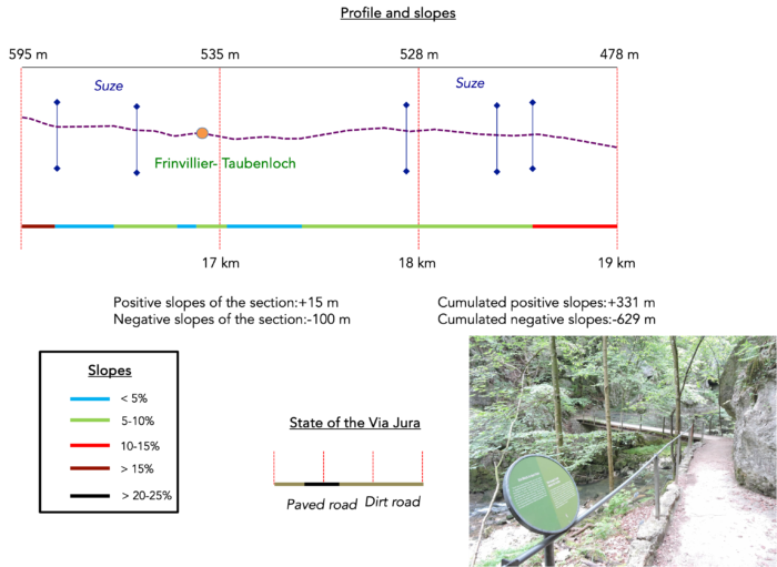
Section 5 : In the Gorges of Taubenloch
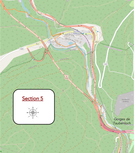
Overview of the route’s challenges : descending path with reasonable slopes.
|
In Rondchâtel, the odyssey on the Via Jura begins on the other side of the Suze River, its roaring waters like a tumultuous poem in the confines of the Bernese Jura. |
|
 |
 |
|
Far from the often-embellished descriptions, reality reveals itself: the road approaches a landfill, cleverly bypassing the highway with a clever detour. The geographical contours here are of a disconcerting complexity, each twist revealing a new facet of the landscape. |
|
 |
 |
|
From there, a small path runs alongside the highway before passing under it a little further down. The geography of this area is decidedly complex. No need to be impatient; the highway will be encountered again further ahead. |
|
 |
 |
 |
 |
|
As soon as the highway is crossed again, a small path winds through the thickets of deciduous trees to reconnect with a wider path below. The constant rumble of the highway accompanies the walk, a reminder that it will reappear further along. |
|
 |
 |
|
Then, once more, the Suze River is crossed, re-emerging in all its swirling splendor after having been left behind at Rondchâtel. The entire route to Bienne is a continuous dialogue with the river, which gracefully cascades through the deep, narrow valley, whispering its secrets along its route. |
|
 |
 |
|
The path then transforms into a dirt road descending under the cliffs, weaving among the leafy trees until Frinvillier. The underbrush here departs from standards of elegance, offering wild and authentic beauty, where the disorder of nature flourishes in rustic harmony. |
|
 |
 |
 |
 |
|
At the village entrance, a tranquil body of water glimmers under the sun, while the bridges crossing the river stand as symbols of human ingenuity: railway, road, and highway stretch out in a metallic and asphalt ballet, uniting the landscape in an almost poetic manner. |
|
 |
 |
 |
 |
|
Frinvillier, the ultimate bastion of the Bernese Jura, reveals a subtle but tangible change: German reclaims its rights, even though Biel claims the title of bilingual city. Here, indications abound, pointing in all directions, but ours remains steadfast: Biel-Bözingen, on the Via Jura 80. Less than an hour’s walk from Biel, the journey promises many more discoveries, between the Germanic language and natural majesty. |
|
 |
 |
|
The Via Jura traverses the first part of the village, then descends toward the river. |
|
 |
 |
|
A delicate path follows the elevated canal of the river, burrowing beneath the village. The place truly brims with grace and charm. |
|
 |
 |
 |
 |
Yet, the Suze persists beneath the foliage, now renamed Schüss in German language. At this stage, knowledge of German becomes crucial, as the route will primarily unfold in the German-speaking part of the country during the upcoming stages.

|
From here, the itinerary heads toward the gorges of Taubenloch. The company operating the gorges built a remarkable hiking trail in 1889 to traverse on foot these gorges sculpted by the river to Bözingen (Boujean in French). |
|
 |
 |
|
The Via Jura then enters the forest that borders the canal. Here, the surveyors danced with the river, guiding it at times while allowing other sections to wander freely, for the pleasure of the eyes and local amenities. |
|
 |
 |
|
A first hydraulic structure reveals itself as the canal rejoins the riverbed. |
|
 |
 |
|
The deeper you walk into the gorge of Taubenloch, the more the enchantment intensifies. The river has patiently carved its path through the rocky barrier, creating swirling eddies, mysterious caves, steep cliffs, and striking spurs. |
|
 |
 |
|
Above, the imposing arches of the highway viaducts brush the sky, framed by the majestic beech trees that persist at every turn of the path. |
|
 |
 |
|
At times, the valley narrows so much that the path had to be carved directly into the rock. Fluctuations in the water level are visible, as evidenced by an old gauge dating back to 1910. |
|
 |
 |
|
Throughout the descent, a series of bridges allows the walker to navigate from one bank of the tumultuous river to the other, slipping between moss-covered rocks in this often-humid atmosphere. The game of moving from one bridge to another, from one rocky ledge to another, becomes a true ballet with nature, a suspended dance that takes your breath away. It’s as if the path itself becomes an accomplice, inviting a sequence of aerial movements between sky and earth, each step revealing a new miracle. Chasms open beneath one’s feet, the bridges tremble in the wind, and the heart races, swept away in a whirlwind of elements. An adventure that draws a smile to the lips and fills the soul with wonder. |
|
 |
 |
 |
 |
|
Halfway through, the trail passes near one of the ESB buildings. The Taubenloch hydroelectric power station, commissioned as early as 1896, stands as a living testament to human ingenuity. The company Brown, Boveri & Cie was tasked with its construction, thereby inaugurating the electrical service of Bözingen. Upon the merger of the municipalities of Biel and Boujean in 1917, the power station became the property of the Biel Electric Service, undergoing transformations and upgrades in 1941/42. Even today, it significantly contributes to the electrical supply of Biel. |
|
 |
 |
|
At times, a modest water retention interrupts the course of the Suze. The riverbed is strewn with large limestone blocks emerging here and there, sometimes submerged when the waters rise. And always omnipresent, the highway tentacles stretch out like a threatening sky. |
|
 |
 |
|
In French, this hydraulic complex is known as Boujean. In German, it is called Bözingen. |
|
 |
 |
|
The path continues to wind beneath the impressive rock faces, crossing from one bank to the other beneath the monstrous arches of the highway. The atmosphere becomes almost phantasmagorical, one might say. |
|
 |
 |
 |
 |
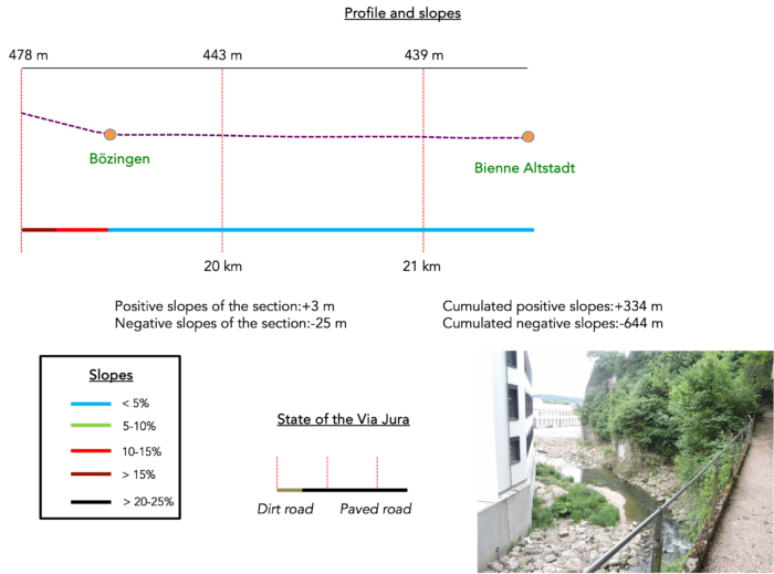
Section 6 : Biel Altstadt deserves a visit
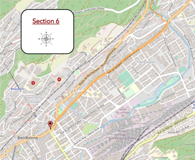
Overview of the route’s challenges : a bit steep at the exit of the gorges, then the city.
|
At the bottom of the gorges, the path sometimes meanders along the rocks, always in harmony with the river that sings softly over the stones. At no point along the route is there any sign of danger. |
|
 |
 |
 |
 |
You gradually approach the end of the gorges. The two imposing highway bridges loom above you, like two concrete giants stretched between the cliffs. Their powerful, rigid arches seem suspended in the air, defying the void in an engineering feat, while their shadow stretches below, enveloping the valley in a veil of shadow and mystery. It is a sight that recalls the quiet strength of the mountains, a fascinating contrast between the untamed nature and human hands, balanced above the world.

|
was a joyful walk of 40 minutes from Frinvillier. Bözingen is just 10 minutes from here. |
|
 |
 |
|
At the bottom of the gorges, the Via Jura 80 reaches its peak. The walls of the gorge tighten, framing the path in an almost intimidating embrace, until they force the way into a dark tunnel. This passage, sculpted into the rock, seems like a secret door leading to the old Bözingen factory, like an industrial enclave hidden in the wild heart of the mountain. The light changes, the rustling of water amplifies, and the atmosphere becomes both solemn and fascinating. The old and new industrial buildings testify to the economic activity nourished by the proximity of the river. |
|
 |
 |
 |
 |
|
The route then emerges from the gorges. As in any good show, there is thunderous applause. |
|
 |
 |

|
The Via Jura 80 ends in Bözingen, where the Schüss River flows through the new town before pouring into Lake Biel. For those wishing to continue their journey toward Geneva and join the Camino de Santiago, it is simply a matter of following the direction of Vingelz. However, Biel deserves an extended visit. And when traveling, finding accommodation for the night is often a good idea. |
|
 |
 |
|
Just follow Rue de Boujean, Bözingenstrasse, to reach the city center. Nothing too surprising on this main axis, but it is also possible to take the bus. In just over a kilometer straight ahead, you will arrive at the heart of the city where the magnificent Altstadt, the old town of Biel, unfolds. However, before you arrive, your eyes might be drawn to the heights of the city where a well-known Swiss jewel shines. But in Biel, it’s not just Rolex that brings fame, as Swatch, Omega, and Tissot also call this place home. |
|
 |
 |
|
With over 55,000 inhabitants, Biel comes alive near the marketplace. To the left, the shopping streets of the city center descend toward the station. |
|
 |
 |
|
But the most captivating part of the city is on your right: the Altstadt (old Town), with its beautiful homes, cobbled streets, and squares adorned with statues dedicated to the canton of Bern. |
|
 |
 |
 |
 |
 |
 |
|
The Church of St Benedict, near the town hall, originally dates back to the Romanesque period in the 13th century. Although it was rebuilt in a Gothic style in the 15th century, it remains today a prominent Reformed place of worship that has left its mark on the city’s history. |
|
 |
 |
Accommodation on Via Jura
- Hôtel Restaurant du Cerf, 4 Rue du Collège, Sonceboz; 032 488 32 22; Hotel***, dinner, breakfast
- Hôtel La Truite, 3 Reuchenette, Péry; 032 485 14 10; Hotel***, dinner, breakfast
- Auberge des Gorges, Taubenlochweg 5, Frinwilier; 032 358 11 75; Hotel**, dinner, breakfast
- Christiane Jordan, 44 Faubourg du Lac, Bienne; 032 322 29 04; Guestroom, breakfast
The Jura is mainly popular among local tourists, so accommodations are limited, apart from some Airbnbs (whose addresses aren’t readily available). On this stretch of the journey, you can find places to stay before reaching Bienne, a larger city with full amenities and numerous shops. For additional lodging options in Bienne, you can contact the Tourist Office at 032 329 84 84 for guidance.
Feel free to add comments. This is often how you move up the Google hierarchy, and how more pilgrims will have access to the site.
 |
Next stage : Stage 8: Frome Bienne to Le Landeron |
 |
Back to menu |