Far above the Birs River
DIDIER HEUMANN, ANDREAS PAPASAVVAS
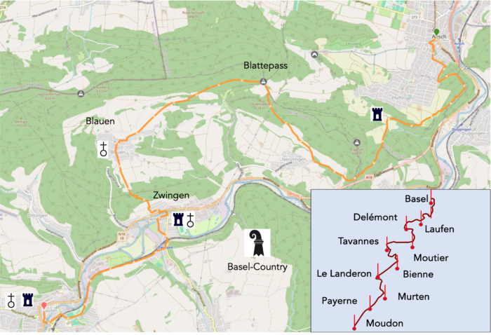
We divided the course into several sections to make it easier to see. For each section, the maps show the course, the slopes found on the course, and the state of the route (paved or dirt roads). The courses were drawn on the « Wikilocs » platform. Today, it is no longer necessary to walk around with detailed maps in your pocket or bag. If you have a mobile phone or tablet, you can easily follow routes live.
For this stage, here is the link:
https://fr.wikiloc.com/itineraires-randonnee/de-aesch-a-laufen-par-la-via-jura-80-174895139
| It’s clear that not all travelers are comfortable using GPS and navigating via smartphone, and there are still many areas without an internet connection. As a result, you find a book on Amazon that covers this journey.
If you only want to consult lodging of the stage, go directly to the bottom of the page. |
|
Yesterday, you strolled along the tranquil banks of the Birs River, allowing its meandering course to guide you, as you gently traced the riverside path shaped by nature’s hand. The overhanging branches of deciduous trees created a verdant archway on either side of the river, offering shade and a welcome coolness. But today, the landscape shifts dramatically. In Aesch, the Birs Valley narrows, enclosed by towering cliffs. Where you might logically expect to follow a peaceful, secure road, the planners of the Via Jura defy expectations. Instead of following the valley floor, they draw you toward the forested heights and alpine meadows, calling you to climb, where the mountains beckon. This is an invitation to explore the « alpine pastures », an enchanting escape along elevated trails far from the monotony of flat paths. Only at the final stretch, in Laufen, will you reunite with the familiar and reassuring banks of the Birs River.
It must be noted that only the most daring hikers attempt the full stretch from Basel to Laufen in one go, without pausing in Aesch. Such a journey would be long and exhausting for most.
.
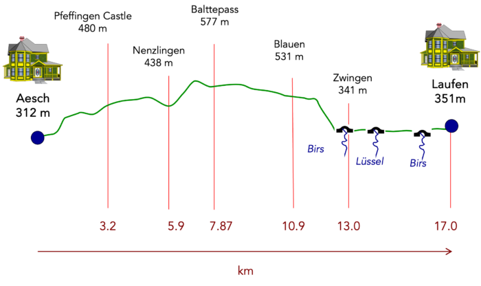
Difficulty level : While the total elevation gain of the stage may seem manageable (+402 meters/-368 meters), the route is not without its challenges. Rather than following the valley obediently, it dances with the peaks, playing with elevation. Thus, this portion proves to be challenging, much like all those that make up the steep paths of the Swiss Jura. Two climbs deserve special attention: the first ascends to Pfeffingen Castle, while the second, far more daunting, leads to the Blattepass. After this, the path becomes more forgiving, except for a brief but demanding descent into Zwingen.
State of the Via Jura : This stage of the Via Jura is a delight for walkers, with most of the route consisting of well-maintained paths:
- Paved roads: 4.9 km
- Dirt roads : 12.1 km
Sometimes, for reasons of logistics or housing possibilities, these stages mix routes operated on different days, having passed several times on these routes. From then on, the skies, the rain, or the seasons can vary. But, generally this is not the case, and in fact this does not change the description of the course.
It is very difficult to specify with certainty the incline of the slopes, whatever the system you use.
For those seeking « true elevations » and enthusiasts of genuine altimetric challenges, carefully review the information on mileage at the beginning of the guide.

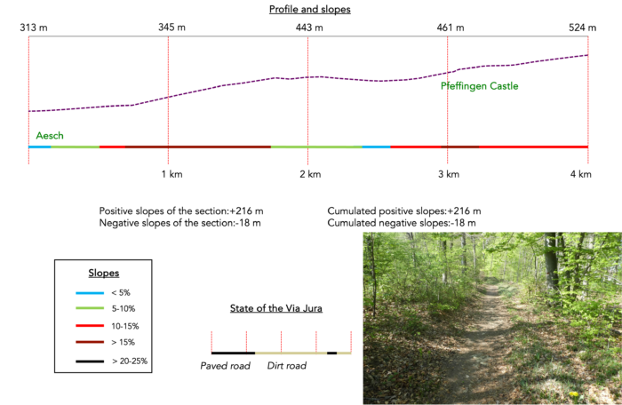
Section 1 : Ascent to the Ruins of Pfeffingen Castle

Overview of the route’s challenges : gradients exceeding 15% in some areas. Even the downhill sections are not particularly gentle.
|
In the heart of Aesch, where the streets are bustling with potential tracks to explore, the estimated walking time to Laufen is four and a half hours. |
|
 |
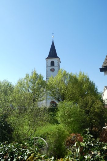 |
| Leaving the town center, you follow a route that first skirts the cemetery before meandering through the suburban outskirts. Your general destination is the ruins of Pfeffingen Castle, and you’ll find various paths leading there. Stick to the Via Jura 80 to avoid getting lost. | |
 |
 |
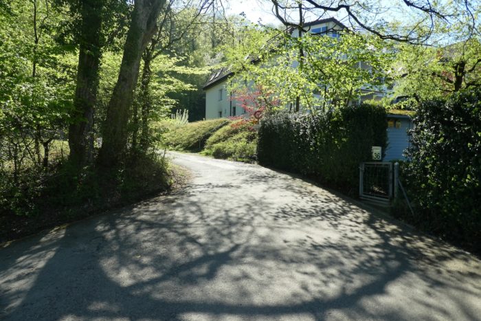
| True to its name, the Via Jura unveils a landscape dotted with discreet villas, sheltered behind tall thuja hedges, standing as silent guardians of privacy. |
|
 |
 |
| As your steps grow more confident, a subtle transformation occurs: the suburbs gradually give way to a majestic crown of forests. Urban life recedes, replaced by the raw beauty of nature. The suburbs stretch up to the forest’s edge, where the gradient becomes steeper, exceeding 15%. The residents of these peripheral neighborhoods rarely venture here on foot, perhaps preferring the intimacy of their own gardens. | |
 |
 |
| At the top of the steep slope, a few modest houses timidly appear. | |
 |
 |
| At the forest’s entrance, a playground provides a welcome break for many hikers, with a bench offering a chance to recharge for the more demanding section ahead. . | |
 |
 |
| Continuing along a rocky dirt path, the ascent becomes gentler, leading toward the summit of Eichberg Hill. This wooded sanctuary, where centuries-old oaks and beeches reign supreme, boasts a surprisingly rich botanical palette: elegant hornbeam bushes, sturdy maples, and even a few proud chestnut trees standing amidst flourishing shrubs. The name « Eich » refers not only to the prolific oaks but also to the majestic beeches that are their equal in splendor. | |
 |
 |
 |
 |
| From this peak, a panorama stretches as far as the eye can see: in the distance, the Roche Tower, a sentinel of Basel’s industrial history, silently watches over the landscape. Below, the enclosed entrance to the Birs Valley reveals Angenstein Castle, perched like a falcon on its rocky spur—a poignant reminder of the power wielded by the feudal lords who once ruled these lands. This fortress, along with the ruins of Bärenfels and Pfeffingen Castle encountered later on, played a crucial role in regional conflicts between the bishops of Basel, vassals of the Habsburgs, and the Counts of Ferrette, their French neighbors. The bishops of Basel, even after adopting the Reformation and relocating to Porrentruy, maintained their status as princes of the Holy Roman Empire, owning the present-day canton of Jura, the Bernese Jura, and Laufental from the Middle Ages until the early 19th century. | |
 |
 |
| The broad, now rock-strewn path slopes up gently through the forest. | |
 |
 |
| The Via Jura, now running along the ridge, skirts cliffs on modest forest trails that wind through deciduous trees, mostly oaks and beeches. The scenery is stunning and wild, with the path often snaking between jagged rocks and the gnarled roots of trees cluttering the way. | |
 |
 |
 |
 |
| The limestone nature of the ridge creates a dramatic backdrop, where slender beeches and majestic oaks dominate the landscape, while smaller maples and hazels cast delicate shadows over the ground. The underbrush creeps along the winding trail. | |
 |
 |
| Below, the semi-highway unfurls across the plain like a ribbon of asphalt leading to Laufen, a vivid reminder of the contrast between the peaceful heights and the constant activity of modern life below. | |
 |
 |
| Among the deciduous trees, a few errant cherry trees can be spotted, their branches laden with blossoms in the spring, adding a poetic touch of color to this natural tableaus. | |
 |
 |
| The path lingers a while longer in this sumptuous woodland setting before gradually beginning the descent… | |
 |
 |
| …until you reach the heights of Pfeffingen, a border village of Aesch, where newly built villas rise from the valley floor to the hilltops—a vision capturing urban development while preserving the natural charm of the region. In the far distance, the Roche Tower in Basel still stands on the horizon, a beacon recalling the presence and industrial history of the city. | |
 |
 |
| A wide path then descends through meadows toward the majestic ruins of Pfeffingen Castle, offering an unparalleled view of the horizon where Basel’s silhouette is clearly visible. | |
 |
 |
| The descent is brief, and soon the wide path climbs again through the meadows toward the castle ruins. | |
 |
 |
| This dirt path eventually joins a small asphalt road that first winds toward Waldschule, an institution dedicated to rehabilitating young people in difficulty, and then toward the imposing castle ruins. Here, the slope once again asserts its dominant presence. | |
 |
 |
Your direction on Via Jura 80 is marked Blauen/Laufen.
| The road finally leads to the castle ruins. The ruins are slightly off the Via Jura trail. | |
 |
 |
This is a spectacular site where tradition tells that these magnificent, mysterious remnants were gifted by the Habsburgs to the Bishop of Basel, along with all the land up to the Alsace border on the left bank of the Birse. Granted as a fief to the Lords of Pfeffingen, the castle later passed through marriage to the Thierstein family, who were in constant conflict with the Bishops of Basel. These struggles continued until the Thierstein lineage ended in the early 16th century, after which the castle returned to the control of the Bishops of Basel. The Thirty Years’ War marked the castle’s irreversible decline, neglected by the episcopal administration, which failed to maintain it.
|
Today, the ruins, owned by the canton of Basel-Country, still bear witness to the grandeur of the Thierstein family, with their bridges spanning the moats, drawbridges, towers, and the oval-shaped residential keep. In 1761, the already uninhabitable buildings were sold for demolition. Recently, the canton generously invested in stabilizing the parts in danger of collapsing, preserving this remarkable heritage and its living memory. |
|
 |
 |
From here, your next notable stop is Blauen, over two hours away.
|
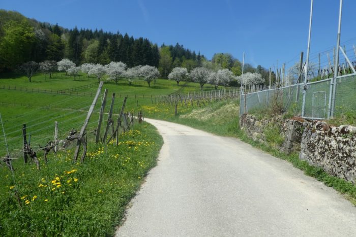
After leaving behind the castle ruins, a forest path briefly plunges into the rough woods, leading to the bright clearing of Kleini Weid, where even a few vineyards find space among the fruit trees. On the horizon, the Eggflue antenna stands tall. |
|
 |
 |
 |
 |
|
Behind the hill, you can still glimpse the castle ruins, set against a suspended landscape of woods and pastures. |
|
 |
 |
|
On the horizon rises the imposing Eggflue antenna, dominating the hilltops or perhaps even the mountain, depending on your perspective. The dirt path then climbs with a more pronounced rhythm toward this landmark. |
|
 |
 |
Though the path does not directly reach the antenna, it levels off slightly before arriving at Grosse Weid, perched at 523 meters in altitude, three and a half hours’ walk from Laufen. If you consult the route map, it’s easy to mistake a certain proximity to the A18 motorway near Nenzligen. However, this is deceptive, as this section of the RN18, temporarily transformed into a highway, actually runs underground through the so-called Eggflue Tunnel. Thus, your steps carry you nearly 200 meters above this tunnel!
Section 2 : Conquering the slopes of Blattepass

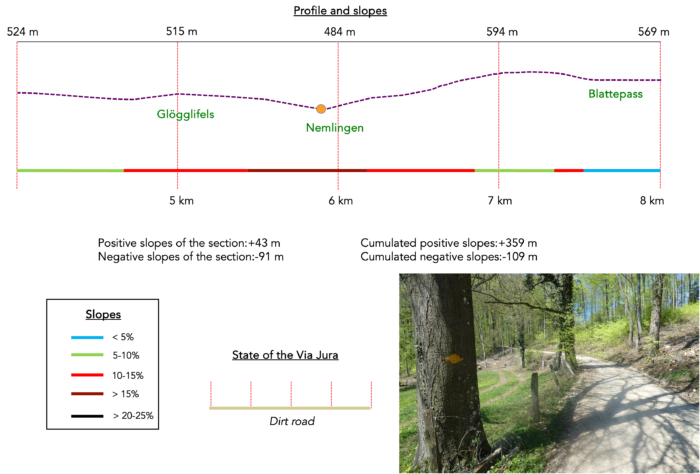
Overview of the route’s challenges : This is where things get serious, with inclines exceeding 15% in some areas.
|
The path meanders and undulates through a mixed forest, where spruces harmoniously blend with deciduous trees. It dips in places only to climb again, each section revealing the wild and striking beauty of this regional forest. The woods become a verdant cathedral, with tree branches intertwining to form a lofty canopy. Sunlight filters through the foliage, casting playful patterns of light and shadow on the forest floor. |
|
 |
 |
 |
 |
|
In this enchanting woodland, infused with natural magic, chestnut and maple trees, like artists seeking recognition, add vibrant colors and textures to the predominantly oak and beech landscape. The gentle incline invites a peaceful walk, a moving meditation through this poetic and captivating scenet. |
|
 |
 |
|
Then, the scenery changes: a brief but steep ascent along a narrow trail leads you to the fascinating site of Glögglifels, the « Little Bell Rock. |
|
 |
 |
|
This site held great importance in the Middle Ages, forming part of the route linking Delémont to Basel. Legend has it that, in addition to the footpath cutting through the forest, a route carved into the rock allowed carriages to bypass the steep cliffs overlooking the valley. On this rock, the coats of arms of Bern and Basel are etched, separated by a vertical groove marking an ancient border between the two cantons. At a time when the canton of Jura did not yet exist, Bern and Basel were close neighbors. It’s said that the sight of a ghostly face and an inscription carved into the stone spurred travelers to quicken their pace. This route avoided customs posts along the Birs River; to secure passage, one merely had to ring the bell attached to the rock, signaling the need for assistance. Of course, the temptation to ring this bell today is irresistible, even if no one answers your call. |
|
 |
 |
Below in the plain, customs officers may have been patrolling, likely turning a blind eye to the passing traffic.

|
The path then weaves through the forest before beginning a steady descent across meadows. It’s best to pass through when no rifles are loaded. Fortunately, Switzerland’s ancient gunpowder tradition seems to be fading, except for the mandatory annual shooting by soldiers, although there are still pockets in Switzerland where these grim practices persist. |
|
 |
 |
|
In the woods, magnificent beech trees stand tall and straight like marble columns, supporting the green canopy above. Their smooth, grey trunks create a striking contrast with the sturdy, gnarled oaks that surround them. These beech trees, like silent sentinels, present an impressive display of height and symmetry, lending the forest a natural cathedral-like atmosphere. |
|
 |
 |
|
Between the verdant fields and groves, the dirt road descends toward Nemlingen, though it doesn’t quite reach the village. At the village’s edge, the Via Jura veers right, climbing towards the Blattepass. |
|
 |
 |
|
The climb to the pass is well worth the effort. While not always demanding, the ascent covers a 150-meter elevation gain over nearly 2 kilometers. The wide dirt road runs above the Ricola headquarters. Yes, you read that right: Ricola, the famous Swiss Alpine herb candy, known and loved worldwide. Nearby, Ricola has established a sort of botanical garden, growing the 13 floral species used in their candies. Could it be a coincidence that not a single cow or farm can be found in this region since leaving Basel? Perhaps it’s to allow the plants to grow in peace, carefully harvested by skilled hands? The Ricola factory is in Laufen, and some say that chemists also work on site. But that’s not your concern. |
|
 |
 |
 |
 |
|
The wide dirt road crunches underfoot, amplifying the sensation of the slope. |
|
 |
 |
As you ascend the meadows, taking your time with each laborious step, you can see a portion of the path that lies ahead. The village of Blauen appears in the distance, while Zwingen can be seen far below in the valley, where you will pass later.
|
The road continues to climb steadily through these sparse meadows, with the occasional rare bench inviting you to rest. |
|
 |
 |
|
Many beautiful walnut trees adorn the fields here. |
|
 |
 |
|
Higher up, the dirt road starts resembling more of a forest trail. It gradually winds through the Cuenisberg forest, where the incline softens. This region seems to primarily cultivate beech trees. The beech, oak, and hornbeam groves create a rich botanical landscape, complemented by flowering plants like sweet woodruff and woodrush. All this is largely influenced by the soil, shaped by factors like humus and pH, whether acidic or neutral—a matter of debate among experts. Beech reigns supreme here, a species that prefers the shade, much like the chestnut. When the soil is deep and fertile, beech trees grow tall and straight, forming natural colonnades. However, on impoverished, rocky soils, their growth is stunted, keeping them short and stocky. Among these beech groves, you also find species that prefer light, such as oak, Scots pine, silver fir, maple, hazel, dogwood, or elder. |
|
 |
 |
 |
 |
A high-voltage powerline pylon marks the summit of this ascent. The Schweiz Mobil organizers kindly lead you up to a point even higher than the pass itself!

|
Through the forest maze of Blauerberg, each step echoes like a symphony of leaves and whispers. The path snakes down gracefully among towering conifers, stately beeches, and graceful chestnut trees, their trunks like solemn columns reaching toward the sky. Their crowns brush against the azure canopy above, striving to capture a piece of the infinite, as if chasing an elusive embrace with the heavens. |
|
 |
 |
 |
 |
|
This narrow path winds through the undergrowth above a modest country road that leads toward the pass. |
|
 |
 |
 |
 |
|
Just a short distance away lies the Blattepass, modest in comparison to the towering Alps, but reaching 571 meters above sea level. There, a picnic area boasts a massive bench where only giants could sit with dignity. Any human attempt to sit here feels futile against this colossal relic, a testament to nature’s grandeur and untamed beauty. At the confusing crossroads of trails, it’s essential to carefully follow Via Jura 80, guiding travelers towards Laufen, still two and a half hours away. |
|
 |
 |
|
The walk continues through the peaceful Blauerberg forest, among tall beech trees whose leaves gently rustle as you pass. The path’s gentle undulations feel like a soft caress, cushioned by a natural carpet of leaves and moss that muffles every step. |
|
 |
 |
Section 3 : Gradual descent back to the plains, through meadows and woodlands

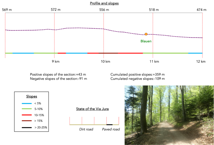
Overview of the route’s challenges : a steady descent, with no major challenges.
|
The forest here is gentle, and the path broad, offering ample shade under the tall trees. |
|
 |
 |
 |
 |
|
Clearings emerge one after another, like ephemeral paintings in the green theater of this preserved nature. Each open space reveals a new facet of the landscape, with light and colors shifting with the changing seasons. |
|
 |
 |
 |
 |
|
The dirt road, called Blattenweg by locals due to its route toward the pass, then leaves behind the dark forest and gracefully winds through meadows where walnut and fruit trees thrive, their branches heavy with the promise of future harvests. |
|
 |
 |
 |
 |
|
Lower down, the dirt path turns into a rough, paved road, winding like a calm river through the pastoral landscape, inviting you to journey and daydream. |
|
 |
 |
 |
 |
|
Soon, the road leads to Blauen, a small farming village perched on the heights. |
|
 |
 |
|
In Blauen, crosses and religious symbols proudly stand, bearing witness to a tumultuous history. In the predominantly Protestant canton of Basel-Country, where about a third of the population is Catholic, the creation of the Canton of Jura in 1978 had a profound impact. This historical event isolated the Laufonnais (the German-speaking region around Laufen, where you are walking) from the rest of the Canton of Bern. After initial resistance in 1983, the Laufonnais finally joined the Canton of Basel-Country in 1989, affirming its Catholic roots, much like the Jura as a whole. |
|
 |
 |
|
From here, you are 45 minutes away from Zwingen and 1 hour 45 minutes from Laufen. |
|
 |
 |
 |
 |
|
As you run through the village, the road crosses a lovely chapel, adding a touch of piety to the peaceful atmosphere. |
|
 |
 |

|
Further down, the Via Jura leaves the main road to follow a dirt path known as Hardweg. In German, this can be literally translated as « difficult path. » However, in the context of place names in Germany and Switzerland, Hardweg often refers to a trail or road that runs through a wooded area, especially a beech forest. Rest assured, this path fits both meanings, suggesting a journey through a wooded and potentially demanding landscape. But at first, the approach is easy, and you’ll cross it with a smile, up to the edge of the forest. |
|
 |
 |
 |
 |
Section 4 : The Via Jura rejoins the Birs River

Overview of the route’s challenges : a brutal descent into Zwingen, followed by easier terrain.

|
As soon as you enter the forest, the slope becomes ominous, like a sleeping giant ready to challenge you. The narrow path twists steeply, covered in a slippery carpet of leaves that whisper underfoot. The surrounding vegetation is wild and creeping, almost embracing you, while the few large trees, absent to catch you if you slip, give way to a dance of shifting shadows. |
|
 |
 |
 |
 |
|
This path, nicknamed « The Impossible » by many hikers and pilgrims, is an unavoidable trial, despite the murmurs and sighs it evokes. In dry weather, it’s already a daunting challenge; in the rain, it becomes a nightmare. The path winds capriciously through slopes often exceeding 35%, offering a near-unparalleled challenge over 500 meters, where each step becomes a heroic conquest. |
|
 |
 |
|
Further down, the slope briefly calms, offering deceptive relief. Emerging from the forest, you see Zwingen at your feet, and a wave of mixed relief and exhaustion washes over you, like the retreat of the tide after giving everything. A strategically placed bench at the forest’s edge offers rest for your joints and muscles after the harrowing descent, while the dizzying view below reminds you that the hardest part is still to come. |
|
 |
 |
|
Indeed, another steep path weaves between meadows and a hedge, deceptively carefree as it snakes toward the village. Every moment on this demanding trail is a tribute to perseverance and the raw beauty of nature, a challenge that shapes both body and spirit. |
|
 |
 |
|
The Via Jura then gently descends along small roads toward the small town. |
|
 |
 |
 |
 |
Religious symbols are also prominent here.
|
You reconnect with the N18 road. By car, the journey from Aesch to Zwingen is only 8 km, taking about 9 minutes. Yet your pilgrimage has surely felt much longer, hasn’t it? |
|
 |
 |
The Via Jura crosses the Birs River, which is calm at this point, to reach the heart of Zwingen, a town of about 2,100 inhabitants.
|
At the end of the main street, the imposing Zwingen Castle stands majestically. |
|
 |
 |
|
Surrounded on three sides by the river, the castle was first mentioned in a document from 1312, when it belonged to the Ramstein family under the sovereignty of the Bishops of Basel. After a long legal battle in the late 14th century, it reverted to the bishopric. From then until the French Revolution, it was home to the prince’s bailiffs. Sold after the Revolution, it passed through various hands before being purchased by the Zwingen paper mill in 1913. Like many paper mills near water, it closed in the early 21st century. Since 1993, the castle has belonged to the municipality of Zwingen, and it now hosts concerts, events, and occasional functions. However, a free visit of the castle is not possible. The castle, once inhabited by bailiffs, comprised two groups of buildings forming two adjoining islands, surrounded by the waters of the Birse, which were channeled into artificial moats. These buildings were connected by three bridges: one led to the valley road, another linked the two islands, and the third, a drawbridge, provided access to the village. Today, part of the castle remains, including the keep and the chapel, while the stables and other outbuildings have vanished over time. Two of the historic bridges remain, attesting to the site’s prestigious past, now partially administered by the commune, as indicated by entrance signs. |
|
 |
 |
|
The Via Jura continues toward the train station, passing well-kept houses of no particular architectural note. |
|
 |
 |
 |
 |
|
Crossing the railway tracks is rather complex. |
|
 |
 |
| On the other side of the station, the Via Jura crosses the Lüssel, a small stream with little water. | |
 |
 |
|
The route then exits the main road, passing by small suburban villas on the outskirts of the town. It follows the Lausanne-Basel railway line. |
|
 |
 |
 |
 |
|
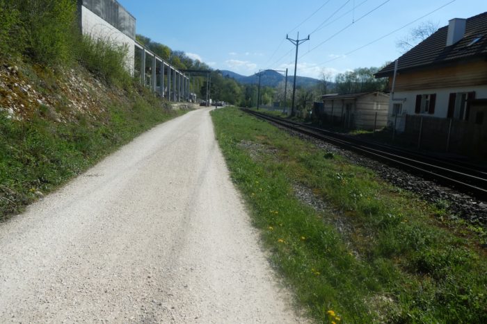
Soon, dirt replaces asphalt, extending the trail along the tracks through the countryside, where nothing is particularly exciting, except perhaps the occasional passing train. |
|
 |
 |
 |
 |
|
Further along, the tranquility of the landscape is disrupted by the presence of an active quarry. The noise of machinery and the constant movement of workers contrast with the serenity of the surrounding nature. |
|
 |
 |
|
Continuing on, the road crosses a small industrial area. The Camino de Santiago often approaches cities by passing through such zones of human activity, where the clinking of tools and the hum of workshops tell another story of human effort. |
|
 |
 |
|
Eventually, the sparse factories give way to more pastoral surroundings, crossing the Diebach stream, which is accompanied by the refreshing murmur of a waterfall further down. |
|
 |
 |
 |
 |
|
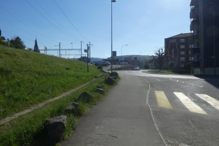
Approaching the small town, you pass by a swimming pool before crossing the railway again. |
|
 |
 |
 |
 |
|
Shortly afterward, the road crosses the Birs River, guiding your steps toward the historical heart of the town. |
|
 |
 |
|
Gradually, patrician houses replace the more conventional suburban buildings. |
|
 |
 |
|
You then enter the lively alleys of the city, arriving at one of the old gates leading to the old town. |
|
 |
 |
|
Here, the architecture is reminiscent of other small Swiss towns, with a particular similarity to Murten. On the Camino de Santiago, you’ll find a similar layout in Willisau in Lucerne, as well as in Le Landeron and La Neuveville near Lake Biel. The central square is lined with patrician houses, boutiques, and shops. Statues add a touch of majesty to the space, which exudes a unique charm, where each architectural element tells a story, and every façade bears witness to the region’s rich past. The shops and businesses add contemporary vibrancy, attracting pilgrims and visitors in a constant dance of activity. Laufen, the capital of the Laufonnais with its 5,600 inhabitants, is closely tied to Basel-Landschaft. Known as Laufon in French, it was once the seat of a French department during the Revolution, before being reintegrated into the Canton of Bern by Napoleon in 1815. Though it borders French-speaking Switzerland, French is rare here, much like German is rare in nearby Delémont. Laufen’s medieval gem is undoubtedly its old town, where a central artery winds between historic gates, especially the Zeitturm (Time Tower). Adorned with an impressive clock and an astronomical dial, this tower encapsulates the charm and ingenuity of the medieval era, frozen in time and history. |
|
 |
 |
Accommodation on Via Jura
- Hôtel Central, Röschenzstrasse 3, St Jakobstrasse, Laufen; 061 761 61 03 ; Hôtel***, dinner, breakfast.
Le Jura demeure une destination prisée avant tout par les touristes locaux. En conséquence, les hébergements se font plus discrets, à l’exception des Airbnb, pour lesquels nous ne disposons pas des adresses. Das cette étape, il n’y a rien avant d’arriver à Laufen, si ce n’est la possibilité de se restaurer à Zwingen. Et à Laufen ce n’est guère le choix pour se loger : il n’y a qu’un hôtel, même si les restaurants sont assez nombreux. Dès lors, si l’hôtel n’est pas disponible, il ne vous reste qu’a essayer les Airbnb sur internet, qui ne sont pas légion non plus dans la région. Réservez donc impérativement à l’avance, pour ne pas passer la nuit à la belle étoile.
Feel free to add comments. This is often how you move up the Google hierarchy, and how more pilgrims will have access to the site.
 |
Next stage : Stzage 3: From Laufen to Delémont |
 |
Back to menu |
